


*Editor’s Note: The “Views from NAU” blog series highlights the thoughts of different people affiliated with NAU, including faculty members sharing opinions or research in their areas of expertise. The views expressed reflect the authors’ own personal perspectives.
 By Patrick Jantz
Assistant research professor, School of Informatics, Computing, and Cyber Systems
The Convention on Biological Diversity facilitates reporting on biodiversity status and trends around the world but many low- and middle-income countries don’t have access to the most up-to-date data. The UN Biodiversity Lab aims to change that, providing state-of-the-art datasets for visualization, analysis and reporting. The launch of the UN Biodiversity Lab 2.0 (UNBL) marks a major milestone in the use of spatial data for sustainable development.
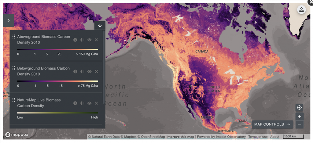
NAU’s Global Earth Observations and Dynamics of Ecosystems (GEODE) lab was an early partner in this effort. NASA funding to our team, led by research professor Patrick Jantz and Regents’ professor Scott Goetz in SICCS, helped us formulate UNBL system functionality, provide datasets and conduct outreach to country partners. With collaborators at Montana State University, the University of Northern British Columbia, the Wildlife Conservation Society and the United Nations Development Program, we developed an approach to use satellite observations to map forest integrity across Earth’s tropical rainforests. High-integrity forests are tall, have minimal human disturbance, maintain high levels of native biodiversity and contain large carbon stores. As such, they are high priorities for conservation. Assessing the accuracy of such products can be challenging, but it is key to gaining acceptance in international conservation initiatives, e.g. the United Nations Convention of Biological Diversity (UNCBD), which is currently being renegotiated. The GEODE lab led by Goetz developed an approach, led by Jantz, that used high-resolution aircraft lidar from the Brazilian Amazon to understand how the forest integrity product performed. We found the pan-tropical dataset did an excellent job of characterizing the structure and condition of Amazon forests. Pat Burns, a GEODE lab member, contributed an analysis of deforestation in high integrity forests using Google Earth Engine, leading to a high-profile publication in Nature Ecology and Evolution. This same effort yielded maps of fragmentation of high-integrity tropical forests. Knowing where loss and fragmentation are occurring most rapidly can help nations prioritize conservation actions to prevent fragmentation of the last strongholds of high integrity forest. Maps of high-integrity forest and their patterns of fragmentation are available to anyone, including conservation planners and policy makers, through the UNBL.
Related research in the GEODE lab focuses on working with three countries in South America (Colombia, Ecuador and Peru) to help identify forests that are most important for maintaining clean water. In each of the three countries, forests are under pressure from logging, mining, grazing and agricultural expansion. Riparian forests along waterways play a key role in maintaining water quality, stabilizing soil, regulating water temperature and mitigating flooding. The first step in quantifying the contribution of riparian forests to stream health is estimating the distribution of forests near stream channels. GEODE lab Ph.D. student Ivan Gonzalez is developing an approach that uses satellite imagery, Geographic Information Systems and hydrological modeling to systematically map riparian buffers, calculate forest cover within those buffers and assess rates of deforestation. These datasets are in the process of being documented and submitted to the individual countries and to the UNBL. More information on this effort can be found in this interactive story map. These data will enable countries to improve their National Biodiversity Strategies and Action Plans (NBSAPS), increase the national roadmaps for biodiversity conservation and enhance reporting on Sustainable Development Goals and the UN CBD’s Post-2020 Global Biodiversity Framework.