


Arizona’s natural resources face increased risk as the climate continues to get warmer and drier. That makes a partnership between Northern Arizona University and the Salt River Project (SRP) even more critical.
This partnership, now in its eighth year, addresses a wide range of pressing issues in the Southwest, including increased wildfire risk, managing endangered and threatened plants and animals, achieving SRP’s sustainability goals and maintaining a reliable water supply.
Learn more about several research projects that are helping protect Arizona.
Tracking a secretive snake through its food sources

Herpetologist Erika Nowak, an associate research professor in the School of Earth and Sustainability, is leading a project that looks at declining food supplies for the northern Mexican gartersnake, a federally threatened species under the Endangered Species Act. The gartersnake lives in river and riparian corridors of central and southern Arizona. As flowing water disappears due to drought and changing water tables and invasive species that outcompete the snake’s native fish and frog prey base become more prolific; the snake is increasingly harder to find.
Nowak, who partnered with Faith Walker from NAU’s Species from Feces program, surveyed portions of Tonto Creek for the snake and the species that it eats. The results: no gartersnakes were detected, and lower diversity and abundance of their prey species compared to other locations in the state where the snake is found were observed. However, these snakes are cryptic, and can be very difficult to detect, even with multiple years of surveys conducted in an area. SRP’s work includes improving the habitat in Tonto Creek where the snakes were previously detected by removing invasive species and introducing native fish and frogs back into the ecosystem as mitigation for Roosevelt Lake water storage and delivery.
Regrowing the Earth’s ‘living skin’ after a fire

Protecting the watershed around the Salt River, which supplies water to more than 5 million Arizonans, includes maintaining a healthy soil surface that isn’t scarred by fire or overrun by invasive grasses. To help this soil heal, an NAU team led by School of Forestry professor Matthew Bowker created and then installed biocrust sods in fire-affected areas. The recently completed project began two years ago, and this summer, the team saw the results of its effort—the biocrust is thwarting the growth of invasive weeds, which contributes to the growth of native plants. This has meant more ecosystem resilience; less soil erosion, leading to better water quality; and more native plants.
“New problems, such as bigger fires in the Sonoran Desert, require new solutions,” Bowker said. “Our work will lead to an enhanced ability to restore burned landscapes, protect infrastructure and water quality through promoting soil-guarding biocrusts.”
Protecting power lines from wildfire
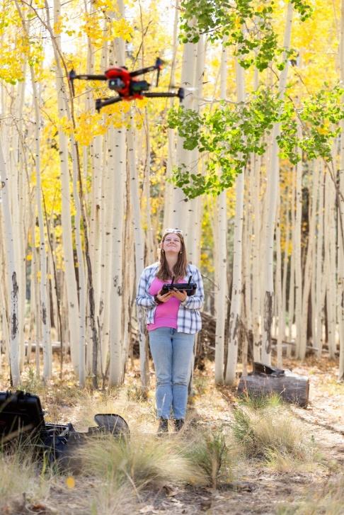
One major risk of wildfires is the threat of power outages, which puts critical functions like cooling services, medical center services and other operations at risk. Regents’ Professor Peter Fulé is leading a team of graduate students and alumni that developed a technique to use drones and lidar to monitor fuel near SRP power line sites. One goal is to create a fuel hazard warning system that shows where the most severe potential fire behavior is located along power line corridors. This gives land and power infrastructure managers additional proactive information on how to protect that infrastructure before and during wildfires. This will be the fourth year of a multiyear research collaboration with SRP on this topic.
Reducing water loss through cracked pipes
The NAU-SRP Pipe Leakage Team, coordinated by mechanical engineering professor Michael Shafer, developed a noninvasive workflow to identify pipe leaks in the previous two phases of this project. The method has been successfully tested on some known leak pipelines in SRP’s irrigation system. In Phase 3 of the project, the research team expanded its scope of work to map a major part of SRP’s CIPP pipelines for leak detection and conduct on-site soil moisture testing for leak validation. The research led to a significant reduction in processing time, which meant leaks were identified and located more efficiently.
Measuring impacts of forest thinning projects
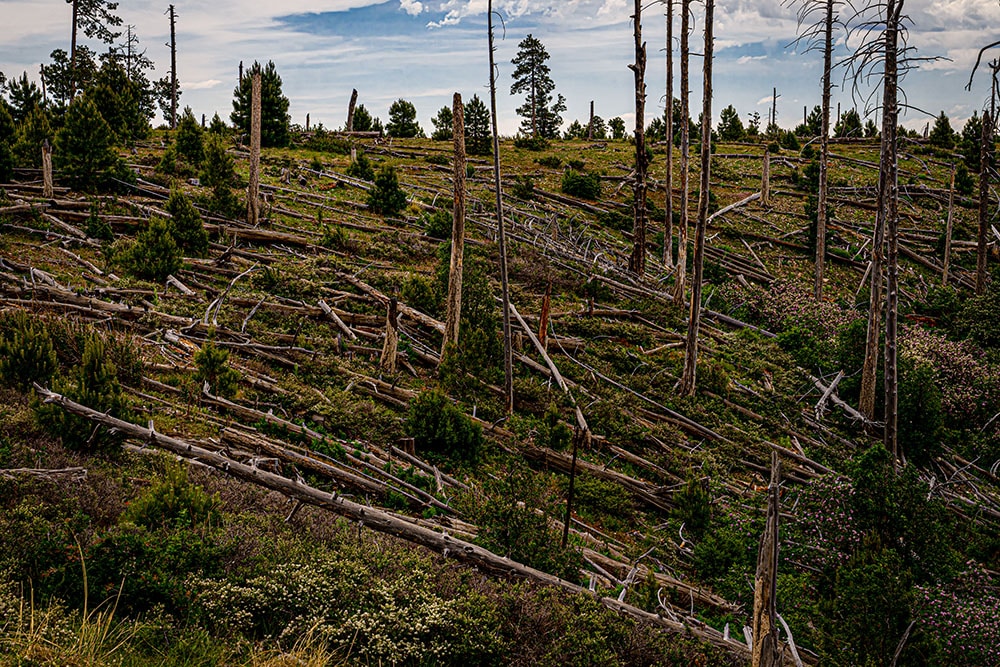
As the risk of severe wildfires grows, forest thinning has become an important prevention technique that land managers deploy in Arizona. A team led by Temuulen “Teki” Sankey, a professor in the School of Informatics, Computing, and Cyber Systems, is examining the impacts of forest thinning in the areas affected by the 1990 Dude Fire near Payson. Researchers found that soils in thinned areas hold more moisture than those in burned and untreated, denser forest areas. The team’s findings indicate that tailored restoration thinning can promote soil moisture availability and drought resiliency in forests. Improving forest health and watershed resiliency is critical to ensuring SRP can deliver on its mission to provide affordable, reliable, and sustainable water supplies.
Mapping the areas at greatest risk from wildfires

A collaboration between NAU’s Ecological Restoration Institute, SRP and Vibrant Planet worked to determine where wildfire risk is highest across more than 14 million acres throughout northern and central Arizona. This information will help SRP protect its resources and determine where strategic restoration treatments will be most effective. This project, which was led by former Ph.D. student Tristan O’Mara, goes beyond traditional maps and numbers to include feedback from diverse stakeholders that captures perceptions of risk, community values, the importance of wildland-urban interface, wildlife habitats and water resources.
“These insights emphasize that effective wildfire risk planning cannot be only about protecting homes or infrastructure,” said Andrew Sánchez Meador, ERI director and professor in the School of Forestry. “It must also safeguard the ecosystems and cultural connections that make Arizona unique.”
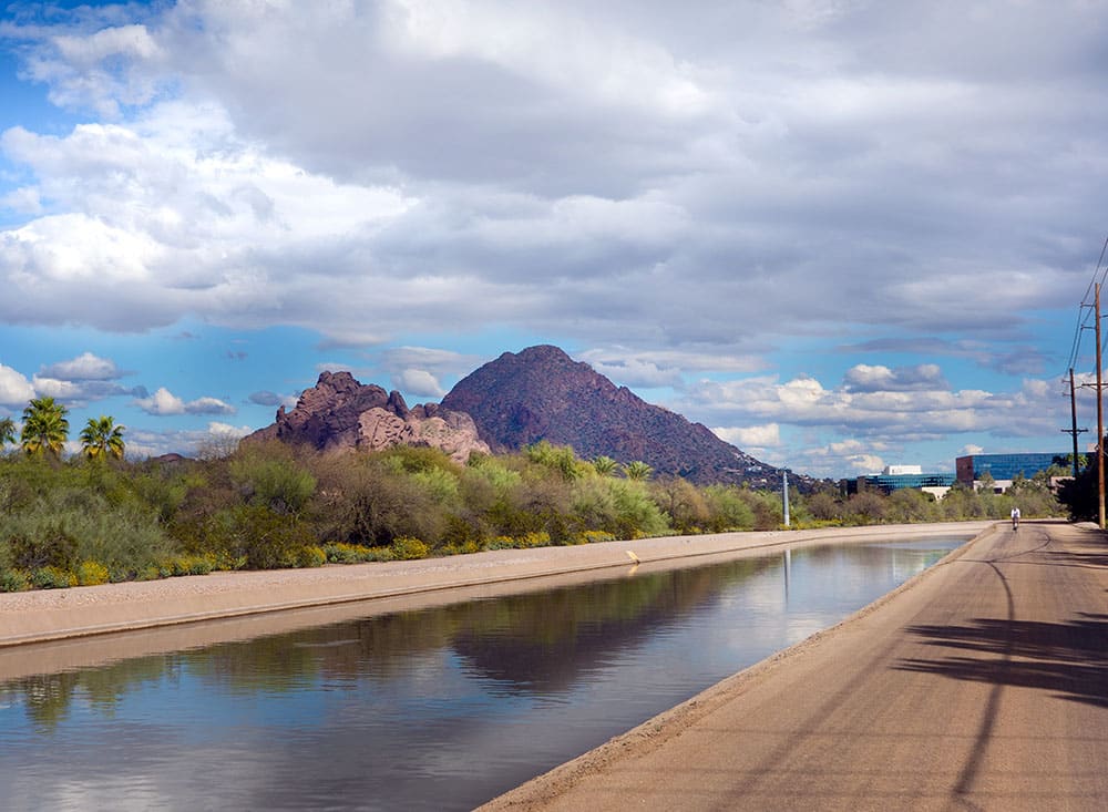
Uncovering deformations in canal linings
SRP provides water to about half of the Valley’s residents, delivering more than 244 billion gallons of water annually. Sediment in canals and deformations in canal linings can lead to serious operations and maintenance issues and potential water leaks. Reza Sharif Razavian, an assistant professor of mechanical engineering, is leading this project, which aims to develop an inspection method using sonar imaging on an autonomous boat system to map sediment and canal lining deformations. With SRP’s support, the team conducted successful field tests along one section of the Consolidated Canal and identified sediment buildup and approximate dimensions.
Heidi Toth | NAU Communications
(928) 523-8737 | heidi.toth@nau.edu