


The Earth Dynamics Geodetic Explorer (EDGE)—a newly proposed NASA satellite mission to monitor the three-dimensional structure of global vegetation and ice—is one of four finalists selected for NASA’s next generation of Earth-observing satellites under the Earth System Explorers Program.
The project, which includes Northern Arizona University assistant research professor Chris Hakkenberg as co-investigator and biodiversity co-lead, will receive $5 million to conduct a one-year concept study. Should the team’s concept be one of two of the four teams selected to advance to the final stage, they will receive a $310 million budget to build the instrument and, with the help of NASA, launch it into space.
 “EDGE could really be a game changer for detailed characterization of global forest structure, allowing us timely and actionable data on carbon, biodiversity and wildfire fuels,” Hakkenberg said. “These data could inform everything from international climate change policy to local conservation planning. And where fuel management for wildfires is a pressing concern, it could even save lives.”
Led by UC San Diego’s Helen Fricker, EDGE is a collaboration of 25 scientists and engineers from around the world. Its goal is to map the 3-dimensional structure of terrestrial ecosystems like forests and the surface features of glaciers, ice sheets and sea ice as they change in response to human activity, ultimately providing actionable data on terrestrial ecosystems and cryosphere change to inform national policies for natural resource management.
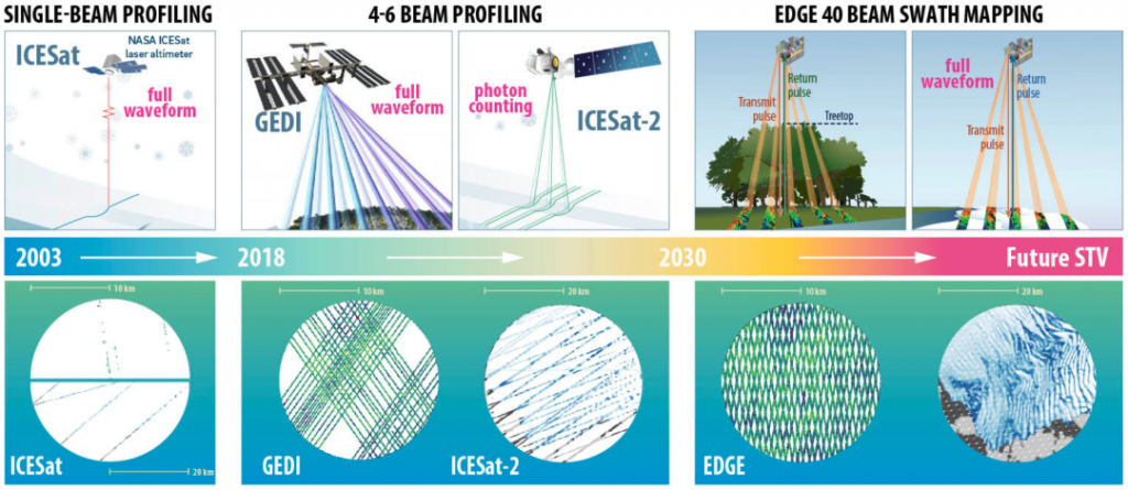
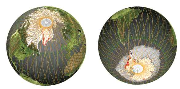
With an increased density of laser beams that will map the planet in five 120-meter-wide strips, EDGE builds on and advances space-borne lidar technology like GEDI and ICESat-2—two previous missions designed to map 3D features across the Earth’s surface. In comparison, EDGE will provide much higher resolution and accuracy, enabling a more comprehensive view of the dynamics of the Earth’s surface. While the GEDI instrument only mapped as far north as southern Canada and as far south as central Chile, EDGE’s orbit extends just shy of the poles, providing global coverage of vegetation and allowing for dense mapping around the edges of ice sheets and sea ice pack.
 “Building upon the many advancements of NASA’s GEDI space-borne lidar, EDGE really takes things to the next level,” Hakkenberg said. “Never before has a space-borne sensor been able to map fine resolution, 3-dimensional vegetation structure across continuous swaths of the Earth surface.”
The unmatched coverage and resolution of the depth, height and structure of terrestrial and ice systems will allow scientists to more precisely measure changes as they are happening, enabling the tracking of carbon stored in forests and ice at the poles. This will provide a real-time look at how the planet is responding to climate change and whether critical tipping points are being crossed, causing abrupt or irreversible change.
Other project collaborators include the University of Maryland, NASA Goddard Space Flight Center, the U.S. Forest Service, George Mason University, Boise State University, the U.S. Geological Survey, Bristol University, National University of Singapore, the Smithsonian Tropical Research Institution, the University of Washington, the State University of New York at Buffalo, Colorado School of Mines, the Australian Antarctic Division and the University of Tasmania.
“I’m looking forward to helping further develop the mission concept study,” Hakkenberg said. “The need to track how the Earth’s forests and ice sheets are changing has never been more urgent. There is no time to waste.”

Carly Banks | NAU Communications
(928) 523-5582 | carly.banks@nau.edu