


A new project at Northern Arizona University aims to provide a flexible set of eyes in dense forest canopy, offering value both to U.S. defense systems and wildfire management in northern Arizona.
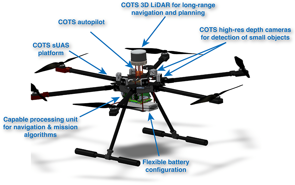
Glasswing is an autonomous unoccupied aircraft system (UAS) that can fly beneath forest canopies, where dense vegetation, unreliable GPS and complex obstacles render conventional drones useless. It builds on work led by Alexander Shenkin, an assistant research professor in the School of Informatics, Computing, and Cyber Systems and director of the ECOSAIL Lab, and lab co-director Amy Wolkowinsky, a geologist in the School of Earth and Sustainability.
It also is one of eight projects funded by a new partnership between the Arizona Board of Regents and the Arizona Office of Defense Innovation. Researchers from all three Arizona universities will develop dual-use technology with the Southwest Mission Acceleration Center (SWMAC) to align university research with defense needs.
“The grant supports a six-month sprint to build out our simulation environment and hardware-in-the-loop testing,” Shenkin said. “By the end of that period, we’ll have a fully functional simulation pipeline where we can test navigation algorithms against realistic forest environments before ever flying hardware.”
The need for Glasswing in Arizona and beyond
Areas with thick vegetation have always been hard to explore—by foot or with technology. That introduces complications when planning for and responding to fires; without knowing what’s there, managers are making critical decisions without all the relevant information.
“Our ponderosa pine forests face wildfire risk, post-fire recovery challenges and climate-driven stress,” he said. “Glasswing enables fine-scale mapping of understory fuels at large scales, better carbon storage estimates for climate and market applications and safer timber planning by identifying hazards before crews enter.”
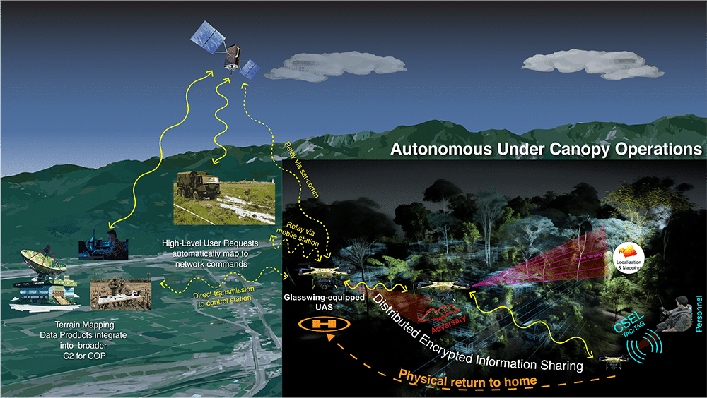
The benefits stretch far beyond our forests, though. Regions throughout the world are invisible to satellites right now; the canopy covers block the view of what’s underneath. Just like in fighting fires, not knowing what’s there is a problem.
“That’s a significant intelligence gap,” Shenkin said. “If you need to plan a mission in that terrain, you’re either sending people in blind or doing without ground-level information entirely.”
Glasswing provides autonomous reconnaissance beneath the canopy, so U.S. forces can map the environment, identify ways in and out and get a better sense of the actual situation on the ground. This is useful for missions like locating downed pilots or lost crew in jungle terrain without putting additional people at risk.
The NAU team is working with Air Force Survival, Evasion, Resistance, and Escape specialists, Shenkin said. The same autonomy that maps carbon in a forest can scout terrain or find someone who needs extraction.
What’s next
The team’s stretch goal is an early version of the system that navigates autonomously in controlled conditions. Beyond that, a grant from the U.S. Department of Agriculture will fund field testing in Arizona forests, accuracy testing against ground-based laser scanning and working with forest managers on real-world applications.

Heidi Toth | NAU Communications
(928) 523-8737 | heidi.toth@nau.edu