


Grain by grain, sandbars are ecologically important to the Colorado River system for humans and wildlife, scientists say. How sand, silt and clay move along and become deposited within the river corridor in Grand Canyon National Park, downstream from Glen Canyon Dam, has become an important question to a number of government agencies as well as Native American tribes. The answer impacts the entire Colorado River ecosystem and will help scientists better understand how the Colorado River system works.
Matt Kaplinski, a senior research associate in Northern Arizona University’s School of Earth and Sustainability (SES), is the principal investigator on a project, “Long Term Monitoring of Sediment Resources and Channel Substrates of the Colorado River in Grand Canyon National Park,” designed to study how the sandbars in the river may be preserved through conservation management.
Funded through a $438,000 grant from the U.S. Geological Survey (USGS), the project goal is to determine the magnitudes and trends in fine sediment storage in the Colorado River ecosystem of the park. To achieve this, Kaplinski will track the effects of flows from Glen Canyon Dam, including planned flooding, or High Flow Events (HFEs), which are part of the National Park Service’s long-term management plan for the Grand Canyon. He also is investigating the interactions between dam operations, sand transport and eddy/sandbar dynamics and monitoring changes in submerged aquatic vegetation along with the material that makes up the channel bed to discern channel sand storage.
“Sandbars are a big part of the river corridor. They form the foundation of the riparian ecosystem and are also where people who visit the corridor camp. Without sandbars, there would just be boulders and talus—debris that falls from the canyon walls,” Kaplinski said. “In order to sustain the system, you have to have enough fine grain sediment to be redeposited from the bed up onto the sand bars. Our main hypothesis is that dam operations can preserve the amount of sand necessary to maintain sandbars over the long term.”
Because most of the sand, silt and clay—about 80 to 90 percent—is stored along the river bottom, a key aspect of the project is bathymetric mapping, which is plotting underwater topography through state-of-the-art multibeam sonar surveys, which Kaplinski adapted to fresh water river systems. “
We started mapping in 2009 and have mapped 150 miles from Phantom Ranch to Diamond Creek several times to measure change,” he said. “The next section to be mapped, from Phantom Ranch to National Canyon, is very exciting because this part of the Grand Canyon has never been mapped with multibeam before.”
Eventually, Kaplinski expects to have a full bathymetric map of the channel and banks of the river corridor, a total of 270 miles.
“Pre-dam, an average of 65 million metric tons passed Lees Ferry’s gauge every year. The dam cut off all of that sediment supply from the upper basin through the Grand Canyon,” he said. “The sediment we are left with is what was there when the dam was built plus what comes in from tributaries below the dam. Fortunately, the Paria River enters at the Lees Ferry area and supplies one to five million metric tons annually. Dam operations designed to maintain sandbars utilize that input from the tributaries to rebuild eroded sandbars. The high flows stir up the sediment and deposit it on the banks of the river. So far, the system seems to be working pretty well.” Kaplinski has been measuring the shifting sand for three decades. “Since high flows have been released, the size of the sandbars is about the same or greater today than they were in 1990.”
As one might expect in the Grand Canyon, sediment movement can be dramatic. “We’ve measured 25-30 vertical feet of change in some pools and eddies before and after HFEs. That’s a massive change,” he said. “We’ve also mapped some surprisingly big rocks in the bottom of the river that were previously unknown and are not really visible from the river. And the river, we’ve learned, can be quite deep – about 80 to 100 feet deep in some places.”
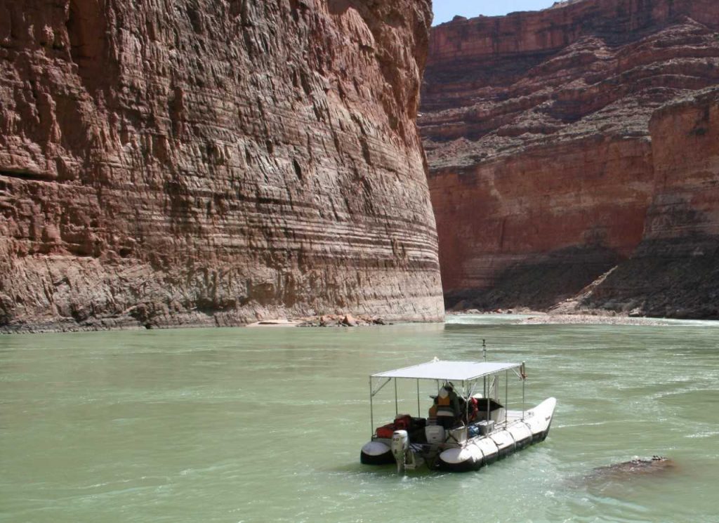
Also involved in the project is Joe Hazel, an NAU senior research associate who specializes in Colorado River sandbar studies. The team includes up to 20 USGS employees, three full-time NAU employees, several undergraduate students and up to 10 people hired to crew river rafting expeditions that haul sophisticated equipment through the Colorado River’s famous rapids.
“All of our research trips are 18 to 22 days long,” Kaplinski said. “We’ve been taking two trips a year since 1990. These river trips are big operations, with six to eight boats and 20-24 folks.”
After the team collects the sonar data, they process it to reveal where the sediment is stored in the system. Researchers also are classifying the river bed material. “From the information we collect above and below the water, we merge several data sets to produce a digital elevation model and bed substrate map of the river corridor,” Kaplinski said.
The sediment study is part of a larger USGS Grand Canyon Monitoring and Research Center program that involves hundreds of local and international scientists and includes research into how dam operations effect native fish populations, as well as other natural and cultural resources. The team will report their findings to the Glen Canyon Dam Adaptive Management Program work group comprised of 27 stakeholders, including state and federal agencies, environmental organizations, recreation groups, power companies and 8 tribes.
The current USGS grant supports the project for one year. Kaplinski believes the findings will help scientists understand other river systems as well as the Colorado River within the Grand Canyon National Park.
Photo credit: Joe Hazel

Bonnie Stevens and Kerry Bennett | Office of the Vice President for Research