


A series of unprecedented droughts in the already impoverished areas of east Africa, chiefly northern Kenya and eastern Ethiopia, have affected millions of people in the region in the past several years, including many refugees from neighboring Somalia.
Although crop failures and resulting food shortages cause severe malnourishment in these populations, the lack of safe drinking water for both humans and livestock also poses a major challenge to governments in this arid region.
NAU scientists to collaborate with USGS hydrologists to develop and share models
Northern Arizona University remote sensing scientist and adjunct research professor Pat Chavez was recently awarded a $270,000 grant by the United States Geological Survey (USGS) to join a project funded by the United States Agency for International Development (USAID), “Investigate the Use of Remote Sensing to Detect and Map Potential Ground Water Resources in Eastern Africa.” Working closely with hydrologists and a digital image analyst at the USGS, Chavez and NAU geospatial scientist Scott Kelly will investigate the use of remotely sensed satellite image data in conjunction with hydrological and geological data to generate models that will identify and map the locations of potential sources of groundwater resources at three study sites in Kenya and Ethiopia.
“USGS hydrological expertise will also be critical to the project,” Chavez said. “The remote sensing data sets and analyses will help identify potential areas of interest based on surface and near-surface landscape characteristics, and the hydrological maps and field data will be used to refine and enhance the results.”
Beyond pinpointing specific areas for local agencies in Kenya and Ethiopia to drill wells, the team will create models based on readily available satellite image and hydrological data sets that can be used in not only other sites within Kenya and Ethiopia, but also in other arid regions of Africa. Once the procedures and models are developed, they will be in the public domain and available for others to use, including other countries or nonprofit agencies.
“The USGS is interested in developing these capabilities and transferring them to other countries for humanitarian purposes—not for profit,” Chavez said.
The resulting models will enable in-country officials to explore and assess satellite image data sets combined with geologic and hydrologic data to help identify potential sources of groundwater. Landscape features the scientists will consider in the project include topography, watershed boundaries, surface slope, geology, fractures, permeability of the soils and vegetation.
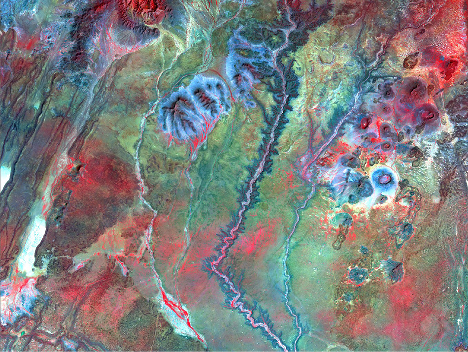
Chavez and Kelly, along with Miguel Velasco, a USGS employee stationed in Flagstaff, will use a wide range of remotely sensed data sets to do their research. Data sets will include satellite images collected by Landsat Thematic Mappers, satellite radar images, a Digital Elevation Model (DEM) collected by the Shuttle Radar Terrain Mission (SRTM), image data collected by the Moderate Resolution Imaging Spectroradiometer (MODIS) and high-resolution images collected by commercial satellites.
The digital topographic image data collected by one of the NASA space shuttle missions will be a key data set to help analyze and map geologic fractures in the areas of interest, which can be important indicators for the presence of groundwater. The radar image data sets will be important, not only because of their high spatial resolution, but also because of their ability to penetrate through several meters of dry soil and sand, which can be used to detect and map historical drainage patterns that are not visible on the surface.
Chavez, the principal investigator on the project and an NAU alumnus, started working for the USGS in Flagstaff when he was a student at NAU in 1970. He became an adjunct research professor at NAU when he retired from the USGS in 2008.
Over the course of his career, he has pioneered the processing and analyses of digital images collected by various satellite, airborne and shipborne imaging systems carrying a broad array of sensors capturing optical, radar, acoustics and Lidar image data sets. Chavez has worked with images to analyze many different types of landscapes, including those on several planets, the bottom of the ocean, the Mojave Desert, Saudi Arabia, North Africa, Alaska, the Grand Canyon and coral reefs in Hawaii. In recognition of his contributions to generating a satellite digital image map of Antarctica in the 1990s, the Advisory Committee on Antarctic Names named Chavez Glacier after him.
What keeps Chavez motivated after more than 40 years in the field?
“Remote sensing is applicable to many different earth science issues and problems, and I have been fortunate to be involved with various interesting research projects during my long career” he said. “Many of the projects, including this one, have a direct application to environmental issues and/or to human health.”
As a hobby, Chavez recently started investigating ways to apply his extensive knowledge, accumulated over four decades, to the medical imaging field.

NAU Research developing capabilities in remote sensing science and emerging technologies
NAU Research is working to develop a strong multidisciplinary capability in remote sensing science. Researchers such as ecologist Teki Sankey use unmanned aerial vehicles, or UAVs, to study forests, sand dunes and other natural features of Arizona. Wildlife biologist Carol Chambers, electrical engineer Paul Flikkema and mechanical engineer Michael Shafer recently worked together on a project to develop a UAV that can track small animals, such as bats and birds, tagged with tiny transmitting tags. Planetary scientist Christopher Edwards uses thermal infrared data transmitted by NASA spacecraft to study the surface of Mars.