


By Kerry Bennett
Office of the Vice President for Research
The boreal forest is home to one-third of the Earth’s forest cover and stores 40 percent of the planet’s terrestrial carbon. North America’s boreal forest alone, which spans the northern portion of the continent from Alaska all the way to Newfoundland, covers an astounding 1.5 billion acres—more than 2.3 million square miles.
As mega-fires in the boreal forest become more frequent and more intense, scientists believe the burning of these carbon-rich areas will drastically increase the amount of carbon being released into the atmosphere. But because these mega-fire areas are so large—more than 10,000 hectares (25,000 acres)—and are home to a complex diversity of vegetation types, accurately predicting these emissions has been challenging.
A recent study completed by a team of Northern Arizona University scientists and published in Global Change Biology was designed to help solve this problem. The first author of the paper was post-doctoral researcher Xanthe Walker of NAU’s Center for Ecosystem Science and Society (Ecoss). The research study included the paper’s senior author, Michelle Mack from Ecoss, and co-authors Ted Schuur from Ecoss and Scott Goetz from NAU’s School of Informatics, Computing and Cyber Systems (SICCS), along with collaborators from the Woods Hole Research Center in Massachusetts, four institutions in Canada, and the Government of the Northwest Territories (GNWT).
“It is vital that scientists can more accurately estimate the carbon emissions from these large wildfires so they can assess the implications of these climate feedbacks on a continental scale,” Walker said. “For example, predicting how these fires will degrade permafrost in the region, reduce the amount of moisture in the soil and affect the soil microbial population all contribute to our understanding of what longer term global climate change may look like.”
Although most people think of it as an area carpeted with evergreen trees, the boreal forest features varied terrains, including lakes and wetlands, and vegetation, including coniferous and deciduous trees, shrubs, moss and lichen.
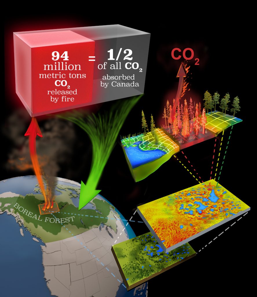
First published estimate of carbon emissions from one of largest fire years on record
By examining 211 field plots in boreal forests of the Northwest Territories in Canada that were burned during an unprecedentedly large wildfire in 2014 affecting 2.9 million hectares (7.2 million acres), the team determined the conditions that led to severe burning and high carbon emissions. They accounted for many different variables, including soil moisture levels associated with landscape position and the presence of permafrost, as well as total tree biomass.
Based on this assessment and the use of high-tech remote sensing products, such as imaging from airborne and satellite instrumentation, the scientists were able to scale emissions to the entire burned region and publish the first estimate of carbon emissions from one of the largest fire years on record in Canada. The team estimated that 94 million metric tons of carbon burned into the atmosphere during those wildfires, about 200 times more than the amount of carbon in the oil spilled during the 2010 Deepwater Horizon explosion in the Gulf of Mexico—considered the worst environmental disaster in U.S. history.
“Our research shows that one large fire year can release half as much carbon as is sequestered by all of Canada’s trees and soil on an annual basis,” Walker said. “As climate warms, we predict large fire years like this will drive boreal ecosystems to be a global source of carbon to the atmosphere, a feedback that will amplify climate warming.”
This paper is one of the first products of the ABoVE project, a $10 million per year NASA field study of environmental change in the Arctic and boreal regions of North America. Goetz leads the 600-member Science Team for the program, and Mack leads its Wildfire Disturbance Working Group.
“The paper is unique in that it combines detailed, on-the-ground fieldwork with satellite remote sensing products,” Mack said. “It is also one of the first collaborative projects between Ecoss and SICCS.”