


April 29, 2019
No matter where you are in the United States, some food in your kitchen probably started its life in Fresno, California.
How do you know? Vegetables, like every other product, follow a supply chain that moves it from where it’s grown to where it’s used. That supply chain can be tracked through data, and that data can paint a powerful picture of how food, water and energy move throughout the United States. The data illustrates how every corner of America is connected.
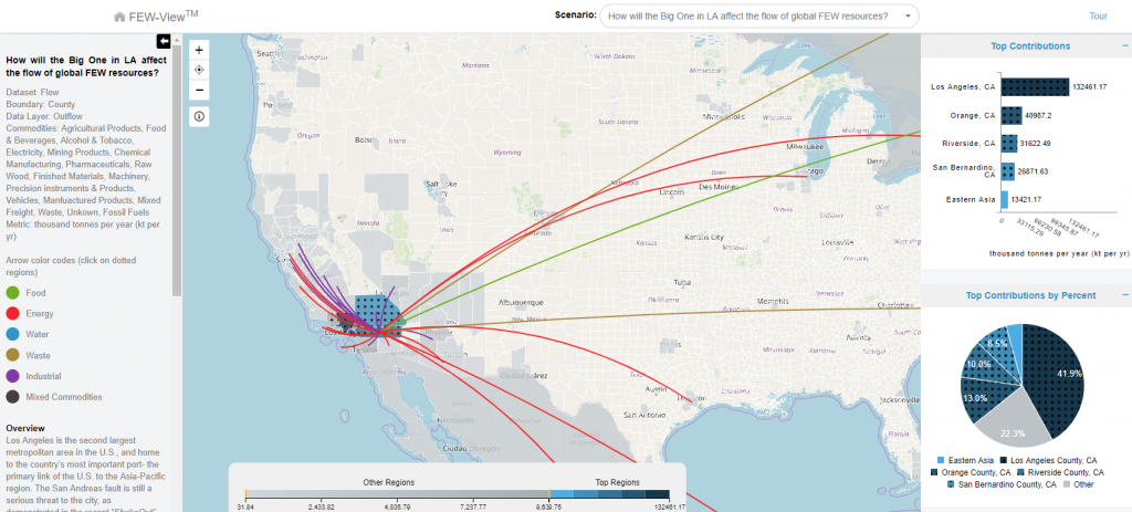
The FEWSION Project is the brainchild of data whisperer Ben Ruddell, an associate professor in the School of Informatics, Computing, and Cyber Systems (SICCS) at Northern Arizona University, who leads a multi-institution team of engineers and data scientists. FEWSION is a data fusion project that maps the food, energy and water supply chains for every community in the United States. Those maps are now available for public use through the FEW-View website, allowing people to see whether their gas prices could be affected by a Gulf Coast hurricane or how much New Englanders should worry about water shortages on the other side of the country. (Answers: Possibly and a lot.) This data was collected by hundreds of researchers at federal agencies and universities throughout the country and for the first time has been put into a searchable and visual form for anyone to use.
“This is a way to see that big data, to see your supply chains, see your lifelines,” Ruddell said. “We look at exposure. If you have a lot of exposure in your supply chain, there is a strong potential for you to be affected by a drought, storm or decision far away.”
With FEWSION, people can map from the sources of their community’s animal products, grains, meat and other foodstuffs; crude oil, gasoline, natural gas and electricity; and water sources. This is useful information for people who want to buy more local products or measure the sustainability of the community’s food and energy consumption, but the purpose of this data is far greater. Ruddell sees FEWSION being especially useful for emergency managers, who can use it to plan ahead if a disaster or situation in some other part of the country is likely to affect their community; and sustainability officers who want to reduce their community’s footprint by changing their commodity sourcing and supply chains. He also encouraged K-12 and higher education teachers to introduce their students to the FEWSION website, which features video, a podcast, news, publications and links to other educational supply chain content and programs.
Richard Rushforth, the lead research scientist on the FEWSION project for NAU, led data development for FEWSION 1.0. It’s a game-changer, he said; FEWSION allows not only researchers but also the public to access large datasets in an applicable way and learn more about where their food, water and energy come from and how different regions of the country are interconnected.
“People want to know: How am I impacted locally? How is something happening on the other side of the country going to affect my life here?” he said. “Being able to have that data on hand visually and to be able to explore it is a really valuable tool.”
For people wondering how to apply the program, here’s an example: FEWSION’s website illustrates the supply chains linking New York City to Otter Tail County, Minnesota; Forsyth County, North Carolina; Bonneville County, Idaho; Monona County, Iowa; Yuma County, Arizona; and about half of California. These connections show more than the routes lettuce, almonds, citrus, fuel and other commodities take to get to the country’s biggest city. FEWSION visualizes the relationships that tie the United States together—relationships that often are invisible to the consumer but are evidence that Americans, for all their differences, are inextricably connected to one another, Ruddell said.
“Rural Americans and urban Americans are different in many ways,” he said. “Their politics are very different, their lifestyles are different, but they depend on each other completely because of their supply chains. In particular, city dwellers need to understand that they get much of their food, clean water and energy from rural Americans and from communities throughout the country. Without this kind of mapping, city dwellers can’t see that connection, and because they don’t see, they don’t understand that they’re exporting their environmental problems and food and energy production to their rural neighbors.
“When you see those connections, you can understand how to vote and spend your dollars in ways that benefit everyone—urban and rural—because we’re all part of the same system.”
In addition to understanding that no city is a resource island, this knowledge also empowers communities to invest in the security, resilience and sustainability of their supply chains.
For example, the current drought emergency the Colorado River is not just a regional problem, Ruddell said. If farms in Arizona or California run out of water, the supply of produce is reduced and the price of healthy, fresh food goes up nationwide.
“Members of the public should know where their food, energy and water are coming from, to understand how connected they are,” he said. “That can affect the way they see the world, and it can make you realize that problems in other places—other people’s problems—are actually your problems too, and that changes everything about the way we see the world. It can change the way we vote, it can change our priorities.
“Information is power—the power to create positive change.”
Ramesh Gorantla, a software development lead at Arizona State University’s Decision Theater and part of the FEWSION team, said project has the potential to enhance the supply chain and make communities more resilient.
“FEW-View provides a simple interface to explore the United States food, energy and water supply chains,” he said. “The tool performs massive big-data computations and displays the queried results in an intuitive way so an ordinary public user can use the data.”
“We all depend on food, energy and water,” said Amy Walton, program director in the National Science Foundation’s Office of Advanced Cyberinfrastructure, which funds FEWSION. “Now, through FEWSION, we can see how what one community does affects its neighbor communities and how a community affects an entire ecosystem.”
See where your community’s food, water and energy comes from and discover how FEWSION can benefit educators, emergency managers, community leaders and sustainability officers by visiting the Visualization page at fewsion.us.
FEWSION was funded in 2016 by a grant from the Innovations at the Nexus of Food, Energy and Water Systems program (#INFEWS ACI-1639529), which is funded by the National Science Foundation and the U.S Department of Agriculture.

Heidi Toth | NAU Communications
(928) 523-8737 | heidi.toth@nau.edu